Uluru-Kata Tjuta National Park
Quick Navigation
Uluru-Kata Tjuta National Park is located toward central Australia in the southwestern corner of the Northern Territory. The national park boundary encompasses an area of 515 square miles (1,333.7 sq km).
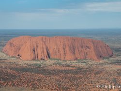
The national park is home to Australia’s renowned Uluru, also known as Ayers Rock, and Kata Tjuta, also known as the Olgas. Uluru and Kata Tjuta are both sandstone monoliths with Uluru being the more popular and most renowned natural feature.
Uluru, or Ayers Rock, reaches an elevation of 2,831 feet (863 m) with a prominence of 1,142 feet (348 m). Kata Tjuta translates to mean, “many heads,” and both places have sacred and traditional value to the indigenous people of the area.
The dome rock of Uluru is comprised of sedimentary rock with sandstone, granite, and basalt. Although Uluru looks like a smooth domed rock from afar, when you get up close you will see an abundance of crevasses and rugged features.
Kata Tjuta, affectionately known as the Olgas, is located about 16 miles (25 km) west of its more famous neighbor. There are 36 domes that combine together to account for this sandstone monolith. The highest elevation is 3,497 feet (1,066 m) with the domes spread out across an area of 8.37 square miles (21.7 sq km). The highest point is known as Mount Olga which features a rise of 1,791 feet (546 m).
Uluru and the surrounding area are not known for wildlife. However, there are 73 species of reptiles found within the park boundaries. The perentie lizard and sand goanna are two of the popular species to see. The red kangaroo, rock-wallaby, camel, fox, rabbit, and the emu are other species of interest.
The Uluru monolith is well known for the way it appears to change colors throughout the day. The different shades of orange and related colors vary depending on the location of the sun.
Highlights
 Uluru, Ayers Rock, is the pinnacle attraction of the national park. Visitors from around the world travel to experience this phenomenon. Kata Tjuta, or the Olgas, is an added bonus, but they are visited far less than the more iconic Uluru.
There are several ways to experience the massive sandstone monolith. Another highlight is the aerial view provided by helicopter. The good news is this often provides a view of both sandstone monoliths. The helicopter does not fly a complete circle around the monolith because one side of it is considered sacred and photography is forbidden.
Although Kata Tjuta and Mount Olga are taller by 650 feet (198 m), this part of the park is far submissive to the iconic Uluru. Together, they are a UNESCO World Heritage Site for both natural and cultural landscapes.
Uluru-Kata Tjuta National Park Trails
One of the best ways is to get out and hike through the various trails which take you up close to the rugged features and crevasses of the monolith.
Uluru-Kata Tjuta Highlights
- Uluru or Ayers Rock
- Kata Tjuta or the Olgas
Park Map
Sources
- All Trails, Best Trails in Uluru-Kata Tjuta National Park, https://www.alltrails.com/parks/australia/northern-territory/uluu-kata-tjua-national-park, retrieved June 2020.
- Australia, Guide to Kata Tjuta, https://www.australia.com/en-us/places/alice-springs-and-surrounds/guide-to-kata-tjuta.html, retrieved September 2019.
- Australia Government, Welcome to Uluru-Kata Tjuta National Park, https://www.environment.gov.au/topics/national-parks/uluru-kata-tjuta-national-park, retrieved September 2019.
- Britannica, Uluru-Kata Tjuta National Park, https://www.britannica.com/place/Uluru-Kata-Tjuta-National-Park, retrieved September 2019.
- Lonely Planet, Uluru-Kata Tjuta National Park, https://www.lonelyplanet.com/australia/northern-territory/uluru-kata-tjuta-national-park, retrieved September 2019.
- Parks Australia, Uluru-Kata Tjuta National Park, https://parksaustralia.gov.au/uluru/, Retrieved September 2019.
- UNESCO, Uluru-Kata Tjuta National Park, https://whc.unesco.org/en/list/447/, retrieved September 2019.


